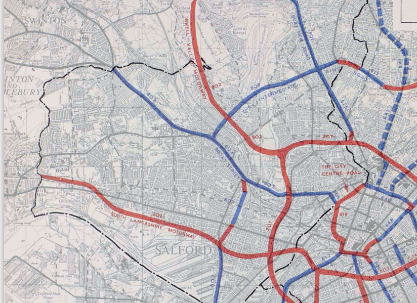
Many drivers in Salford today use the M602, which links inner Salford to the M60 and M62 via Eccles.
However, plans from the 1960s could have made Salford look very different to how it does today.
Proposed plans by South East Lancashire and North East Cheshire Passenger Transport Executive (SELNEC), the precursor to the Greater Manchester transport executive, would have seen motorways and major roads built in the city.
SELNEC’s Highway and Engineering committee were looking to combat traffic delays by creating more roads to relieve busy routes.
Titled “A Highway Plan 1962”, it set out the plans to create a network of motorways across the region, including in Salford.
Among the plans was the Irwell Valley Motorway, which would have linked what was at the time the M62 (now the M60) to a inner ring road around central Salford and Manchester city centre.

This motorway, which would have been numbered the M601, would have started around Phillips Park in Prestwich.
It would have roughly followed the Manchester, Bury and Bolton canal and the railway line that connects Salford and Bolton.
The road would have gone through Clifton, meaning the Viaduct would have almost certainly been demolished.

Then, it would follow the River Irwell through Lower Kersal, Pendleton and cut through the north of Peel Park and it would meet the planned inner ring road in Lower Broughton.
It is unclear why the motorway was never built, but many other similar projects were abandoned to save money.
In total, the Irwell Valley Motorway would have cost Salford Council £8m in 1962. Adjusted for inflation, it totals up to £136m today.
The M602 would also have been very different. The motorway today follows the train line connecting Manchester and Liverpool, but this was not the original plan.
Under the 1962 plans, it would have joined up with what is now the M62 going towards Liverpool, and become the M52.
This road would have linked up with the ring road in North Ordsall and was named the South Lancashire Motorway.

Many houses throughout Ordsall would have been destroyed, built at a cover level to minimise the division the motorway would have caused in the area.
Its route would also be different, moving further south of where it currently is, running much closer to the Salford Quays before meeting Trafford Road.
These plans were shelved when it was decided that the M62 should instead run across the country and use the rest of the South Lancashire Motorway to connect it to Liverpool.
The left-over section became the M64, later renumbered to be the M602, being completed in 1981.
With plans of the Salford Vision showing what the city could look like in the future, it is interesting to see how the city could have looked like if plans like the Irwell Valley Motorway went ahead.


2 Comments